Revolutionizing geological surveys: the impact of LiDAR technology on Earth's surface and subsurface mapping
Ana Rouxinol
LiDAR has emerged as a transformative technology across countless industries, and geology is no exception. By capturing highly accurate 3D maps of the Earth's surface, LiDAR is helping geologists uncover hidden features, monitor dynamic processes, and tackle some of the planet's most pressing challenges.
From mapping fault lines to tracking glacier retreats, LiDAR is revolutionizing how we understand and interact with the Earth. In this blog, we'll explore the incredible applications of LiDAR in geology and how this technology is shaping the future of Earth sciences.
Why LiDAR is a game-changer for geologists
LiDAR uses laser pulses to measure distances and create detailed 3D models of the Earth's surface. Its ability to penetrate dense vegetation and capture minute topographic details makes it an indispensable tool for geologists. Here's what sets LiDAR apart:
- Unmatched precision: captures sub-meter accuracy, revealing subtle, invisible geological features to the naked eye.
- Rapid data collection: covers vast areas quickly, even in remote or challenging terrains.
- Versatility: works in diverse environments, from arid deserts to dense rainforests.
Key applications of LiDAR in geology
1. Mapping fault lines and earthquake hazards
One of the most critical applications of LiDAR in geology is the mapping of fault lines. By creating high-resolution 3D maps, LiDAR helps geologists:
- Identify active fault lines and assess seismic risks.
- Study tectonic movements and predict earthquake-prone areas.
- Monitor changes in topography that may indicate future seismic activity.
While LiDAR enhances earthquake hazard assessments, it's important to note that predicting earthquakes solely based on topography remains challenging. LiDAR is one piece of a broader approach that includes geological, seismic, and historical data.
2. Monitoring volcanic activity
Volcanoes are dynamic and often unpredictable, but LiDAR provides a safe and effective way to study them. Key applications include:
- Tracking changes in volcanic landscapes to predict eruptions.
- Mapping lava flows and understanding their impact on surrounding areas.
- Creating 3D models of volcanic craters for research and monitoring.
3. Mineral exploration and resource management
LiDAR is a powerful tool for locating and analyzing mineral deposits. It helps geologists:
- Identify surface features associated with mineral-rich areas, such as rock outcrops and erosion patterns.
- Plan mining operations by providing detailed topographic data.
- Reduce exploration costs by pinpointing areas with high resource potential.
LiDAR doesn't replace traditional exploration methods but is a complementary tool, enhancing efficiency and improving decision-making during the exploration phase.
4. Studying glaciers and permafrost
As climate change accelerates, understanding its impact on glaciers and permafrost is more critical than ever. LiDAR enables geologists to:
- Measure ice thickness and volume changes, providing insights into glacier dynamics.
- Monitor permafrost thaw and its environmental consequences.
- Study the long-term effects of climate change on polar and mountainous regions.
The precise data LiDAR provides is instrumental in understanding the rapid changes occurring in these sensitive ecosystems.
Real-world examples of LiDAR in geology

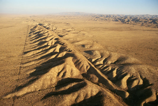
San Andreas fault: LiDAR has been used to map this infamous fault line, revealing previously unknown features and improving earthquake risk assessments.
Iceland's volcanoes: researchers use LiDAR to monitor Iceland's active volcanoes, providing early warnings for eruptions.
Glacier retreat in the Alps: LiDAR has documented the dramatic retreat of glaciers in the European Alps, offering critical data for climate change studies.
These examples illustrate how LiDAR is used in real-world geological studies to advance our understanding of the Earth's dynamic processes significantly.
The benefits of on-site LiDAR systems
Access to reliable and efficient LiDAR systems is crucial for geologists and researchers working in the field. Modern LiDAR systems, like AP-LiDAR-One Gen II and AP-LiDAR-M Gen II, provide:
- High accuracy: delivering sub-centimeter precision for detailed geological mapping.
- Portability: lightweight and easy to deploy in remote or challenging environments.
- Rapid data processing: streamlined workflows for quick analysis and decision-making.
- Versatility: suitable for various applications, from fault line mapping to glacier monitoring.
These features make on-site LiDAR systems an invaluable tool for geologists looking to gather accurate data efficiently and effectively.
The future of LiDAR in geology
As LiDAR technology continues to evolve, its applications in geology are expanding. Here's what's on the horizon:
- Integration with AI: combining LiDAR with artificial intelligence to analyze geological data faster and more accurately.
- Portable LiDAR systems: handheld and drone-mounted LiDAR devices for fieldwork in challenging environments.
- Global climate studies: using LiDAR to monitor large-scale geological changes caused by climate change.
LiDAR is revolutionizing geology, equipping geologists with the tools to map out the Earth's surface and subsurface with unprecedented accuracy. From producing fault maps to monitoring volcanoes and recording glacier retreats, LiDAR is helping us better understand our world and tackle some of its most challenging issues.
As this technology advances, its potential to revolutionize geology and many other fields is limitless. Stay tuned to our blog to read more about the incredible world of LiDAR and its applications.