

LiDAR Data Processing: Why On-Site Processing is the Future
Ana Rouxinol
Processing LiDAR data has traditionally been a time-consuming task. Many companies rely on office-based processing, which requires transferring data back to a central location, waiting for files to upload, and depending on a stable internet connection. This can result in delays and extended project timelines, time that could otherwise be spent moving forward with decision-making and action plans.
At Aerial Precision, we believe in streamlining this process. Our LiDAR sensors offer on-site processing capabilities, allowing you to process your data in minutes, right in the field, using just an iPad. This innovation in LiDAR software cuts down on processing time, saves costs, and avoids delays that traditional methods face. Here's why on-site LiDAR data processing is a game-changer for aerial mapping and surveying industries.

Taking the Office to the Field
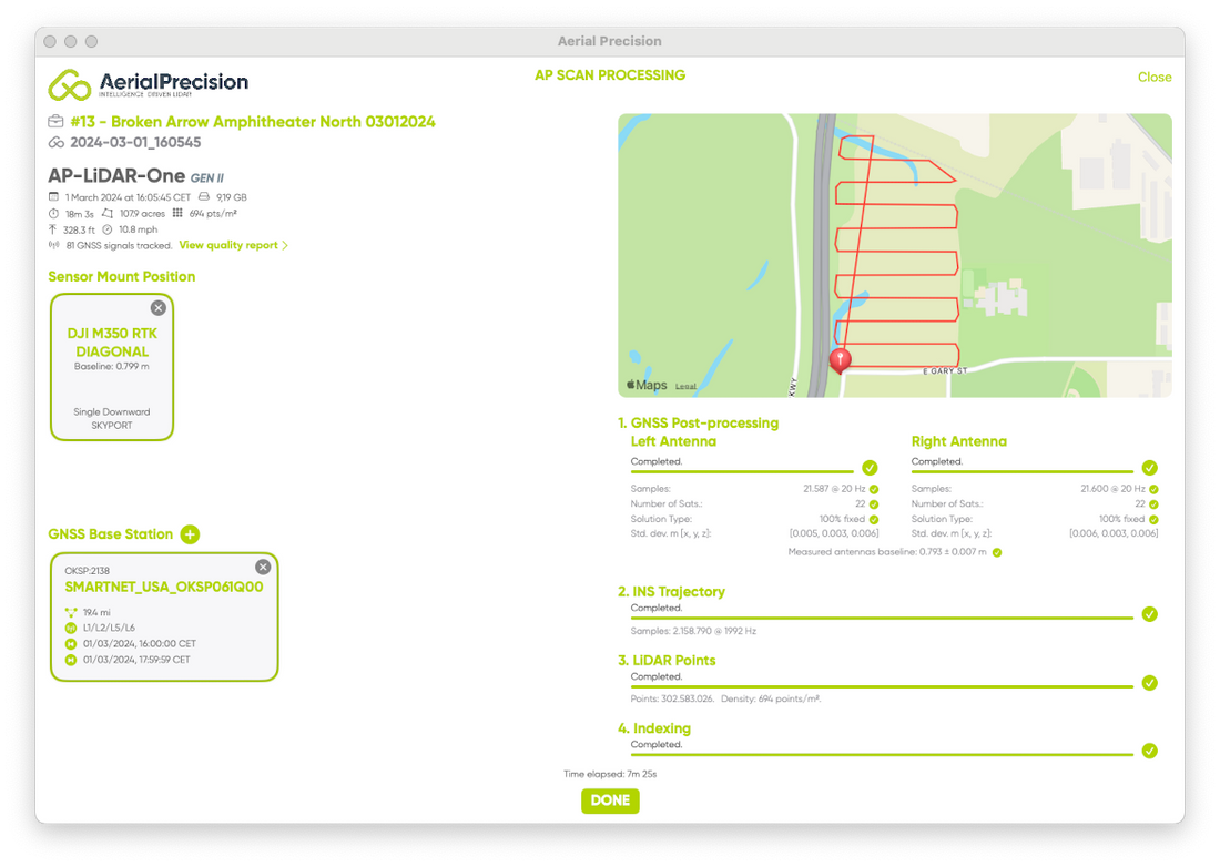
Imagine collecting LiDAR data and immediately processing and visualizing it while still on-site. This is no longer a vision for the future! It's the present, with Aerial Precision's LiDAR systems. Instead of relying on slow, internet-based cloud processing, our system allows you to perform LiDAR data processing right where you are. You can review the results on an iPad, ensuring the accuracy of your data and addressing any potential issues before leaving the location.
This "office in the field" approach dramatically reduces the risk of needing costly rework later due to incomplete or inaccurate data. You get immediate feedback, which means you can double-check your scans and be confident that your data collection is complete before completing the job.
Speed and Efficiency: Process in Minutes, Not Hours
Traditional LiDAR data processing often requires returning to the office, uploading data to a server, and relying on powerful desktop machines or cloud-based services to process point clouds and 3D models. Depending on the size of the dataset, the available bandwidth, and server capacity, this can take hours, if not days.
In contrast, Aerial Precision's on-site processing offers a much faster alternative. With our LiDAR mapping software, you can process your data in minutes right there on-site. This cuts down on waiting times and allows quicker decision-making, helping you keep projects on track.
 No Need for Internet Connection
One of the significant downsides to traditional LiDAR processing systems is their reliance on an internet connection, especially when dealing with cloud-based solutions. If you're working in remote areas, poor connectivity can seriously disrupt your workflow, leading to delays in data uploads and extended processing times.
Recently, cloud service disruptions, such as the Microsoft outage, left companies without access to crucial data. These cloud failures can bring operations to a standstill, causing unexpected delays and frustration.
With Aerial Precision, you don't have to worry about cloud crashes or internet connectivity.
Our sensors and software work without internet access. You can process your data anywhere, whether deep in the forest, in remote construction zones, or miles away from any office. The processing happens directly on the device, and you get instant results, making it perfect for industries that often work in less connected environments.

Simplifying Workflows and Reducing Costs
Another critical advantage of on-site LiDAR data processing is its ability to simplify workflows. Traditional workflows involve multiple steps, from collecting field data to transferring files and waiting for processing. These steps take time and often involve additional costs, such as higher cloud storage fees or the need for specialized software.
Using Aerial Precision's LiDAR software consolidates your workflow into one seamless process. You collect and process the data immediately in the field, cutting down on the back-and-forth between the field and the office. This ultimately helps reduce project costs, as less time is spent on data transfer and processing and more on actionable tasks.
Quality Doesn't Compromise Speed
A common misconception is that faster processing leads to lower quality. However, with Aerial Precision's LiDAR mapping software, you don't have to choose between speed and quality. Our sensors and software are designed to deliver accurate, survey-grade results, even with faster processing times. The same level of accuracy you would expect from office-based processing can now be achieved right in the field, ensuring that your data is always up to par.
No Hidden Fees
One final aspect that sets Aerial Precision apart is our commitment to transparency. Our app, which is included with the sensor, doesn't require extra costs or subscription fees. Unlike many cloud-based platforms that charge additional fees for data processing or storage, our system allows you to process your LiDAR data on-site without worrying about hidden costs.
The Future of LiDAR Data Processing is On-Site
The ability to process LiDAR data on-site without needing an internet connection or additional fees represents a significant shift in how aerial mapping and surveying industries operate. By taking the office to the field, Aerial Precision offers a unique combination of speed, efficiency, and quality, allowing professionals to process their data in minutes, make informed decisions, and keep their projects on schedule.
Contact us today if you're looking for a faster, more efficient way to handle your LiDAR data. Discover how Aerial Precision's LiDAR software can help you save time, reduce costs, and improve your workflow—all without sacrificing the high quality and accuracy you depend on!


